
El Boquerón National Park: crater views, trails, fees, and visitor tips
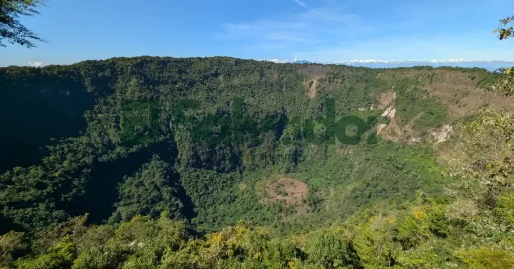
El Boquerón National Park sits on the edge of the San Salvador Volcano, where the big crater steals the show. The main draw is El Boquerón itself, a huge open bowl with steep green walls and a view that can stop you mid-sentence.
People come here for easy hiking, cool mountain air, and a fast break from the city. I remember a taxi driver saying the weather could change in minutes, and he was right, one moment it felt sunny, then the mist moved in and the crater vanished.
The park matters because it shows a clear volcano landscape in a simple, walkable way. If you like geology made friendly, this is a good place to see a stratovolcano up close and learn how crater and caldera landforms shape the view.
The guide ahead covers the trails, entry fees, what to bring, and the small visitor tips that saved us time, water, and a few tired feet.
Key Crater Takeaways
- Crater highlight: the main draw, wide views and a raw volcanic feel.
- Hiking: short walks, steady footing, and dusty trail edges.
- Hours and fees: check local opening times first, and expect a small entry cost in many cases.
- Bring: water, sun protection, closed shoes, and a light layer.
- Best timing: early morning or late afternoon for cooler air.
- Stay nearby: simple guesthouses, small hotels, and town stays close to the crater road.
Understand the park’s volcanic character
El Boquerón is the crater on San Salvador Volcano, not just a pretty hole in the ground. The name can be confusing at first, but the idea is simple, the volcano is the bigger mountain, and El Boquerón is the crater feature inside it.
It formed after a major eruption shaped the summit into this huge bowl, and the volcano has erupted more than once over time. The view feels calm now, but the rocks and steep walls still carry that volcanic story.
Landscape of the Volcano and Crater Area
From the overlooks, the first thing you notice is how the slopes fall away in wide, dark sweeps toward the crater. The rim feels close enough to trace with your eyes, and the whole bowl gives the area a quiet, enclosed look that makes every trail feel a little more dramatic.
You can hear wind moving across the open ground, and the bare rock, ash, and rough paths make the land feel raw and stripped back.
Flora and Fauna in the Park
The crater interior is not barren at all, and that surprised me. Birds call from the trees, reptiles slip through the undergrowth, and mammals move quietly in the shade, while the lush forest and dense foliage make the whole place feel alive.
Watch the crater floor more closely, because the vegetation changes fast with the slope and light. Begonias grow naturally here, and that mix of species is part of what makes the park feel so rich and unusual.
Climate Conditions in the Park
Weather in the park can feel different from nearby towns, so bring layers and expect changing conditions once you start walking. A sunny trail can turn breezy in the open quickly, especially when you stop to catch your breath or sit near a lookout. Good shoes, a light jacket, and a little flexibility go a long way, and that usually makes the whole visit feel more comfortable.
Getting to the park
The park sits on the northwest side of San Salvador, and the volcano makes it easy to spot from the city and even from Santa Tecla. The simplest route sooner, because most people get there by car or taxi, and Uber usually works too.
From downtown San Salvador, the drive is usually about 20 to 30 minutes, depending on traffic. Drivers often use local roads like Avenida Jerusalén, Carretera al Volcán, and CA-1, then follow the signs with the volcano right there in view, which makes the last stretch feel oddly easy after the city noise fades.
Park fees and entrance permits
Park entry is usually checked at the gate, so it helps to have your permit sorted before you arrive. I’ve had that awkward pause at a dusty checkpoint, with the sun already hot and a taxi driver waiting behind me.
- Hours: Not provided in the source, so check the current park notice before you go.
- Fees: Not provided in the source, so bring cash or confirm the rate ahead of time.
- Free-entry exceptions: If the park offers a free-entry day or a local exemption, staff should apply it at the gate.
Here’s the thing, entry rules can change by season or visitor type. Ask the hotel desk first, because the clerk there knew the gate routine better than I did.
When to visit and how to plan your day
Start with the park hours, because the opening window can feel shorter than it looks once you add driving, parking, and a quick stop at the Visitor Center. The calmest visits usually start early, with cooler air, softer light, and fewer cars at the pullouts.
If you only want the viewpoint, plan a short stop near opening and save the rest of your day for something else. If you want a hike, go to the Visitor Center first, check trail conditions, and then give yourself enough time for the walk back before closing.
Getting around inside the park
Parking near the entrance is usually tight, and cars can spill along the access road when it gets busy. A local shop owner pointed us to a spare spot, and that kind of help can save a lot of circling in the dust and heat.
Inside the park, hiking is the only real way to move between sights, so hiking trails matter more than any road map. Wear sturdy shoes, because the ground can be uneven, and the trail feel changes fast after rain.
Highlights Worth Seeing
- The crater, especially the numbered craters that mark the old vents, is the big draw. I remember stopping there first because the 1917 change made the whole place feel bigger than I expected, and the view gives you the best sense of what shifted. See the geology section for the backstory.
- The Visitor Center is where we almost didn’t stop, but I’m glad we did. The displays help the 1917 change make sense fast, and it’s where you can grab maps, ask questions, and cool off before heading out to the trails.
- The Glass Pavilion is worth a pause if you like a clear view without rushing. It tends to be where people linger, listen to the wind, and plan their next move toward the trail section, which makes it an easy practical stop as well as a pretty one.
Things to do on the trails
The trail choices are easier once you sort them by effort. We saw families sticking to the marked paths, while stronger hikers headed for the crater rim and then down into the rougher country below.
- Marked trails, best for a light walk and quick views. They’re the easiest way to get a feel for the park without a big climb.
- Sendero Principal, a good middle option if you want more time on foot. It usually gives you a clearer sense of the terrain and the smells of wet earth and dry rock.
- Crater rim walks, with wide views and steady walking. These are a nice pick if you want the scenery without a full descent.
- Rim-to-bottom hikes, for deeper crater hikes and the hardest effort. One route takes about half an hour to ascend, so save it for when your legs are fresh.
If you’re planning your day, it helps to pair the trail with getting around inside the park. A taxi driver told us the steepest paths look short on a map, then feel much longer once you’re breathing hard and hearing your own shoes scrape the stone.
What to pick up near the park
Near the park, small shops usually cover the basics, snacks, water, and a few handy extras. Grab what you need before the walk back, because once the paths got quiet, the little stalls were harder to find.
One shopkeeper pointed me toward simple things that travel well, and that felt about right. Keep it general, carry light, and save room for whatever smells good on the way.
Places to eat and grab food
The easiest food options are along the park road, so it’s simple to stop before you head in. I still remember how nice it felt to grab something quick while the road was busy and the smell of hot food drifted out from the stalls.
Staying hydrated
Water sources are available along the park, but I wouldn’t count on them as your only plan. A refill from my reusable water bottle saved us from dragging our feet back through the heat.
Bring your own bottle, sip often, and top up whenever you pass a source. It’s a small thing, but it makes the walk feel a lot calmer, especially when the air is dry and the trail is longer than it looks.
What to Bring for the Crater and Trails
- Water bottle. We almost didn’t bring enough, and the dry air felt brutal fast. See the hydration tips for more on water bottle planning.
- Sturdy shoes. The trail gets rough in spots, and loose rocks can slide under soft soles. The trail notes have more on sturdy shoes.
- Boots. If you want extra grip and ankle support, especially on uneven ground, boots make sense.
Where to stay overnight
Nearby city lodging is the easiest move for a park visit. Staying in San Salvador or Santa Tecla gives you more lodging options, easier taxis, and a calmer early start before the day gets hot and busy.
Camping in the backcountry with permits
Permits usually come first, so I’d check the Visitor Center before heading out. Camping is allowed in the backcountry, and the most talked-about spot is down at the bottom of the main crater, next to El Boquerito, where I saw a few tired-looking backpacks lined up by the trail and smelled wood smoke in the cool air. Ask about fees there too, because the desk is where the rules feel the clearest and the whole thing stays pretty practical.
Staying safe around the park
Sturdy shoes made a bigger difference than I expected. The paths can feel uneven in spots, so I was glad I wore proper boots and stayed on the marked trails the whole time.
High viewpoints need a little extra care, especially if vertigo sneaks up on you. I kept my steps slow, stayed behind barriers, and focused on the view instead of the edge.
Where to go after your visit
- Santa Tecla, a good next stop for an easy town break.
- San Salvador, if you want a bigger city stop next.
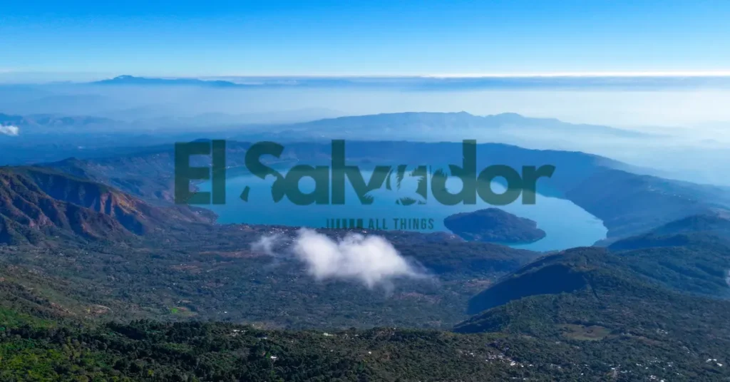
- Cerro Verde National Park also pairs well with other western El Salvador nature stops if you want a longer volcano-focused itinerary.
If you want a lighter adventure stop after hiking the crater trails, the Rainbow Slide El Salvador offers a very different experience from the volcano landscape. Travelers interested in combining volcanoes with archaeology often also visit El Salvador’s Maya ruins during the same trip, and if you are exploring western El Salvador for several days, Tazumal ruins fit naturally into the same volcano-and-history route.
Travelers heading east after San Salvador sometimes also continue toward Conchagua Volcano for Gulf of Fonseca viewpoints. If you prefer slower nature stops after volcano hikes, Los Tercios Waterfall near Suchitoto is another easy add-on.
Geology and eruption history
The active stratovolcano sits inside a crater made by repeated eruptions, collapse, and later lava and ash build-up. Older eruptions, including a 17th-century event, helped shape the steep walls and nearby fissures, while lava flows spread across the land and changed how the crater looked and drained. The 1917 eruption then blasted through the crater floor, altered the crater lake, and left behind Boqueroncito, a smaller crater that still marks that violent change.
Travelers interested in deeper Salvadoran history sometimes also include the El Mozote Massacre Memorial alongside volcano and archaeology routes.
Visitor Center and facilities
The Visitor Center is the easiest first stop if you want the park to make sense fast. We almost didn’t stop, but the exhibits helped us connect the lava stories, the overlook stops, and the bigger volcano picture before we headed out.
It also works as the practical hub for trip details, from current park information to permits and other basics. If you’re thinking about staying longer, it’s a good place to sort out the camping plan before the day gets busy.
Conclusion
El Boquerón’s crater views make the trip feel bigger than the short drive from San Salvador. We almost didn’t go because it looked too easy, but the rim paths, cool air, and that wide green bowl below made it one of the clearest wins of the day.
If you want the simplest plan, pick one viewpoint, take a light walk on the hiking trails, and leave room for a slow coffee or snack nearby. The park works best as an easy half-day stop, especially when you want fresh air without a long haul.
For the least stress, check the planning notes before you head out, then just show up early and let the crater do the rest. If you only remember one thing, make it this, El Boquerón is an easy day trip that feels close, quiet, and a little unreal.
Frequently Asked Questions
What is El Boquerón National Park known for?
It’s known for the huge crater of the San Salvador volcano and the cool mountain air. The views are the big draw, and on clear days you can see far across the city and beyond.
How do I get to El Boquerón National Park from San Salvador?
The park is a short drive from San Salvador, usually by taxi, rideshare, or a private car. The road climbs steadily, so the trip feels quick but a little winding.
How much does it cost to enter El Boquerón National Park?
Entry fees can change, so it’s best to check the current fees before you go. Carry small cash, because that made things easier at the gate.
What are the park hours for El Boquerón National Park?
Park hours can vary by season and local rules, so confirm them before your visit. It’s smart to arrive earlier in the day for cooler weather and better light.
How long does it take to hike the main trail at El Boquerón?
The main trail is usually a short walk, not a long hike. Most visitors finish it in under an hour, depending on stops for photos and the pace of the climb.
Is there a Visitor Center at El Boquerón National Park?
Yes, there is a visitor area where you can get basic information and orient yourself. It’s a handy first stop if you want to ask about the trail or crater views.
Can you camp in El Boquerón National Park?
Camping is not a common activity here, and overnight stays are usually better planned outside the park. If you want to sleep nearby, check the where to stay overnight options instead.
What should I bring to visit El Boquerón National Park?
Bring water, comfortable shoes, and a light layer for the cooler air up high. I also liked having sunscreen and a camera, since the overlook felt bright and breezy.
Is El Boquerón a volcano or a crater?
El Boquerón is the crater of a volcano. People often use the names together, but the famous bowl-shaped view is the crater itself.
What is the difference between El Boquerón and Boqueroncito?
El Boquerón refers to the large main crater, while Boqueroncito is the smaller crater nearby. They are related sights, but the big crater is the one most visitors come to see.
Where can I eat near El Boquerón National Park?
You’ll find small restaurants and local food spots near the park road. After the walk, a simple meal and a cold drink feel especially good in the mountain air.
Where should I stay overnight near El Boquerón National Park?
Most travelers stay in San Salvador or in nearby mountain-area lodging. That usually gives you more dinner choices and an easier start the next morning.
What can I do after visiting El Boquerón National Park?
A common next stop is back in San Salvador for food, coffee, or another city sight. If you still have energy, pair it with another nearby go next stop for an easy half-day trip.