
Weather and Climate in El Salvador by Season and Region
El Salvador has a tropical climate, with a dry season and rainy season shaping travel in most regions and areas. I’ll keep this guide focused on comfort and safety, so you can plan confidently.
Key Takeaways
- Dry season usually brings calmer skies and easier beach days.
- Rainy season means heavier showers, sticky heat, and quick weather changes.
- Coastal, inland, and higher spots can feel very different on the same day.
- Beach danger can jump fast, with rough surf and stronger currents after storms.
- Safety risks rise with wet roads, sudden squalls, and slippery paths.
- Best timing for outdoor plans is usually early day in dry months.
El Salvador’s Tropical Savanna Climate
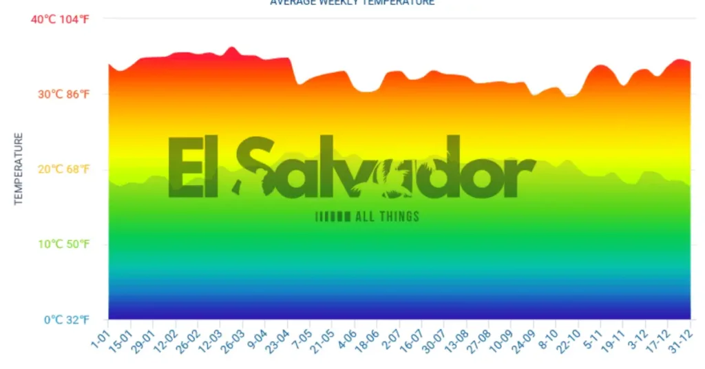
El Salvador has a tropical savanna climate, so the weather stays fairly steady all year. Most days sit between 20°C and 30°C, and the big change is really the rain, not the heat. I remember stepping out in San Salvador in the morning, then hearing those quick afternoon tropical showers roll in like clockwork.
The year splits into two clear seasons. The dry season, called verano, runs from November to April. The rainy season, or invierno, lasts from May to October, and about 75% of annual rainfall falls during those wet months. If you’re checking trip timing, the weather resources page helps with forecast planning, and the best time by activity guide makes the seasonal choice easier.
Truth is, daily comfort changes more with humidity and afternoon downpours than with temperature swings. In the dry season, streets feel hotter and dustier, while the rainy season brings greener hills, heavier air, and sudden showers that can cool things off fast. The taxi driver and hotel staff both said the same thing: bring a light rain layer, no matter the month.
Temperatures by Geographic Zone
The same country can feel like three different trips, and altitude is the big reason why. On the Pacific Coast, the air stays warm and salty, while the central plateau around San Salvador feels milder. Up in the highlands, night lows drop fast, and the interior valleys sit somewhere in between.
Pacific Coast
The Pacific Coast is the steamiest stretch, with nights around 23 to 25°C and daytime highs near 32 to 34°C. The ocean water stays warm too, around 28 to 30°C, so even a swim feels like bathwater. That sea breeze helps a little, but it still feels hot on your skin by midday.
I remember stepping out of a taxi near the beach and feeling that warm salt air hit me right away. If you pack for this zone, think light clothes first, then check the packing section for anything you might need for cooler stops inland.
Central Plateau and San Salvador
The central plateau sits around 700m, so it usually feels more comfortable than the coast. Around San Salvador, daytime highs often reach 30°C from September to November, and about 33°C from March to April. Because of the altitude, evenings can cool down fast, and during Norte winds from December to March, night lows can dip to 13°C.
That swing surprised me the most. One hotel staffer told me to keep a sweater close, and they were right. If you like mild days and cooler sleep, this zone often fits best, especially if you compare it with the best time by traveler type notes.
Highlands
The highlands feel cooler still, especially near Cerro El Pital, which rises to 2,730m, or 8,957ft. Higher altitude means thinner air and lower temperatures, so evenings can feel crisp even after a sunny afternoon. NASA Earth Observatory notes that elevation strongly shapes local temperature patterns, and it shows here right away.
Interior Valleys
The interior valleys sit between the heat of the lowlands and the chill of the highlands. They usually feel warmer than the plateau at night, but less sticky than the Pacific Coast during the day. The lower altitude keeps temperatures steadier, and the reduced sea breeze makes the air feel calmer and drier.
That balance is why these valleys can feel easy for day trips. You still notice warm afternoons, but you won’t get the same sharp temperature drop you feel in the highlands.
Pacific Coast Warmth, La Libertad, El Tunco, Acajutla
The Pacific coast stays warm year-round, which makes beach days feel easy in La Libertad, El Tunco, and Acajutla. Daytime highs usually sit around 32 to 34°C, while nighttime lows stay near 23 to 25°C, so even after sunset it still feels soft and humid.
The ocean water temperature runs about 28 to 30°C, which is why surf sessions and swimming both stay comfortable most months. The heat here doesn’t really change much, so you can pick your dates without overthinking the weather.
San Salvador and the Central Plateau at Around 700m Elevation
At about 700m elevation, San Salvador and the central plateau usually feel much more temperate than the coast. Daytime highs can reach 30°C from Sep to Nov, then climb closer to 33°C in Mar and Apr, but the air still feels lighter up here. I remember a taxi driver laughing as we rolled past the capital, saying the mornings were “gentle” until the sun got serious.
Here’s the thing, nights can surprise you. During Norte winds from Decto Mar, temperatures can drop to 13°C, so evenings may feel chilly even after a warm day. If you’re planning city visits, this milder best time by activity window is one reason the plateau stays popular, and I’d keep a light jacket handy from the packing section. According to the USGS, altitude is one of the most reliable reasons places like this stay cooler than the coast.
Highlands of Santa Ana and Cerro El Pital
The mountainous areas around Santa Ana and Cerro El Pital stay cooler because of the altitude. Santa Ana is usually the coldest stretch, and Cerro El Pital, which rises to 2,730m, or 8,957ft, can even see a winter snow phenomenon in some years.
That temperature drop makes sense, since higher ground usually means lower temperatures and bigger swings between day and night. If you’re heading up for a hike, I’d keep an eye on volcano hiking and pack for layers in our packing notes. A taxi driver in Santa Ana joked that you can feel the cold before you even see the ridge, and he was right.
Interior Valleys of the Sonsonate Region
Sonsonate is usually the hottest and wettest part of this area, especially in the interior valleys. I remember a driver telling me the heat feels stronger in the wet season because the sea breeze doesn’t reach inland as well, so there’s less relief and the heat intensity hangs around longer. If you’re planning comfort around the wetter months, timing matters, and the activity timing notes help a lot.
Detailed Climate Calendar for Trip Planning
The weather here shifts fast, and that changes how a trip feels. I still remember a taxi driver laughing when I said I might hike in the wettest month, then pointing at the clouds like, not today.
November to February: high season comfort
This is the high season, with about 8 hours of sunshine a day, 25 to 30°C temperatures, about 4 rainy days a month, and only about 18mm of rain. November and March can be the warmest months, but this window still feels bright, dry, and easy for outdoor plans, so it’s a good time to lock in the best time by activity choices early.
March to April: end of dry season heat
By March and April, the dry stretch turns hot, and daytime highs can reach 35 to 38°C. Plan early starts, lighter walks, and indoor breaks if you want to keep the best time by activity plan comfortable.
May to June: rainy season onset
The rainy season onset starts to show up here, and the air can feel sticky with humidity rising toward 85%. This is also the start of hurricane season, which runs from June to November, and NOAA and the National Hurricane Center note that storms can still send heavy rain inland even without a direct hit.
July to August: moderate wet season
Rain becomes part of the routine, but it often comes in bursts instead of all day. Roads can smell earthy after showers, and hotel staff usually know exactly which afternoons stay clear enough for a market run or a beach walk. Plan flexible days, quick-dry clothes, and backup indoor stops if you want the best time by activity picks to still work well.
September to October: peak rainfall risk
This is the highest-risk stretch, with 21 to 24 rainy days a month and up to 300mm of rain. Expect torrential rains, sudden flash floods, and muddy roads that can close fast, so I’d avoid September for mountain hiking and check the safety section before setting plans. If this is your only travel window, plan low-risk activities and keep your route loose.
November to February: Peak Dry-Weather Season for Visits
November through February is the ideal time to visit if you want dry and sunny days and fewer rainy days. Expect about 8 hours of sunshine a day, warm temperatures around 25 to 30°C, and only about 4 rainy days a month, with roughly 18mm of precipitation. I remember a taxi driver in San Salvador saying, “This is the easy season,” and he was right, the roads felt calmer, and even short city hops were less of a hassle.
The dry-season comfort makes it easier to pace your itinerary, from city visits to beaches and swimming, and it’s smart to check the packing guide before you go. For most travelers, these are the warmest months to plan around, with sunshine that tends to hold up best across the trip. According to the World Bank Climate Change Knowledge Portal, this period matches El Salvador’s typical dry-season travel conditions.
March to April: Dry Season’s Final Stretch and Peak Heat
March and April are the hottest months, with daytime temperatures often reaching 35 to 38°C. In the interior valleys, the heat can feel even sharper, and by April the air starts to turn heavier as humidity creeps in and the approaching rains edge closer.
I remember stepping out into clear mornings, then getting hit by sticky, tired afternoons that made even the taxi driver laugh and say, “Drink water first.” If you’re planning around the hydration and packing advice and the weather-by-region section, this is the time to be extra careful.
May to June: Rains Start and Hurricane Season Begins
May usually brings the first daily late-afternoon showers, and by June the air feels heavy enough to stick to your skin. Temperatures still sit around 25 to 30°C, but humidity can climb to 85%, so mornings are the easiest time for walks, market visits, or boat rides.
Since hurricane season runs from June to November, it helps to keep afternoons flexible and check local weather more often. For rain gear and timing advice, see the packing guide and safety precautions.
July to August: Moderate Rainy Season with Shorter Bursts
July and August are hot and humid, with rains frequent but often packed into a few hours. Most mornings still bring enough morning sun for a walk, a market visit, or a quick boat ride before the sky changes. I remember one hotel staffer saying, “go early, then hide out with a cold drink,” and that turned out to be solid advice. If you can, plan outdoor time earlier in the day, then keep your rain gear close for the afternoon activities and packing.
September to October: Peak Rainfall and Higher Disaster Risk
September is the month I’d avoid for mountain hiking. This is peak rainfall, with 21 to 24 rainy days a month and up to 300mm of rain. The rain comes often and hard, so roads can wash out fast, and the ground gets too soaked to hold. That’s when floods, landslides, and flash floods become much more likely, especially on steep routes. I remember a taxi driver in the hills shaking his head at the sky and saying, “The mountain changes fast here.” He wasn’t kidding.
Because the rain is so frequent and concentrated, drainage systems and trail edges can get overwhelmed in a short time. If you’re planning mountain hiking, check the climate risks page and the safety resources before you go. Government hazard-monitoring updates, like those from the Ministry of Environment and Civil Protection, are especially important during this period.
Climate Risks and Safety Precautions
Hurricanes, heavy rain, and sudden flooding
Hurricanes rarely make direct hits here, but they often veer north and still dump dangerous rain. That means the real problem is usually torrential rains, flash floods, and landslides, not the storm’s eye itself.
I still remember a taxi driver in San Salvador shaking his head at the sky, saying, “The rain does more damage than people think.” He was right. Amanda and Cristobal in 2020 caused 30 deaths and affected 600,000 people, and the June 2024 floods killed 13 people and displaced over 4,000.
Urban flooding and road safety in San Salvador
San Salvador is especially vulnerable to urban flooding. Water can rise fast on busy roads, drain covers overflow, and low spots near riverbanks can turn messy in minutes. I’ve seen shopkeepers drag stools onto counters while cars hissed past in brown water.
Here’s the thing, movement planning matters as much as weather watching. If a storm is building, leave early, avoid night driving, and never try to cross flooded streets. Even shallow water can hide potholes, open drains, or stronger currents than they look. This guide on how to get around El Salvador becomes especially useful during rainy months, when landslides, floods, and delays can affect routes quickly.
- Watch Protección Civil and the Ministry of Environment first for alerts.
- Stay off roads near riverbanks, steep slopes, and low crossings during heavy rain.
- Rework your day if warnings mention landslides, floods, or flash floods.
- Do not drive through moving water, even if other cars do.
- Keep your phone charged so you can receive alerts fast.
- If rain gets intense, head indoors and wait it out.
- For beach days, check the beach safety section before going near the coast.
Travelers comparing Uber vs rental car in El Salvador should know rainy-season driving becomes much riskier after dark or during flash-flood warnings.
Hurricane Season (June to November): Indirect Flooding Impacts
Hurricane season runs from June to November, and the biggest danger is often the indirect effects, not the storm’s center. I remember watching dark water race past a hotel curb while a taxi driver shook his head and said the rain was the real threat, not the wind. Torrential rains can trigger flooding, landslides, and road closures far from any direct landfall.
That happened in 2020 with Amanda and Cristobal, which left 30 people dead and affected about 600,000 people. In June 2024, floods killed 13 people and displaced more than 4,000. If you’re traveling, keep an eye on weather resources for alerts, and check the urban flooding section if you need to move around cities. According to El Salvador’s Ministry of Environment, Protección Civil,and MedioAmbienteSV, official alerts are the most relevant source during storm events.
- Avoid rivers and low areas. Water can rise fast after heavy rain.
- Skip flooded roads. A road that looks shallow can hide strong currents or washouts.
- Follow official alerts. Check Protección Civil and MedioAmbienteSV before you move.
- Plan for delays. Landslides and street flooding can stop buses, taxis, and airport transfers.
Heavy rain can also delay trips to and from the main El Salvador airport, especially during the peak rainy months.
Urban Flooding: Why San Salvador Can Flood So Fast
The San Salvador metro area can see urban flooding quickly when intense rains hit and drainage systems get overwhelmed. Streets that looked fine a minute ago can start pooling fast, and water may push through low spots, underpasses, and busy intersections.
I remember hearing a taxi driver mutter, “here we go,” as the rain came down hard and the smell of wet pavement filled the air. If you’re moving around town, allow extra time for commutes and transfers in heavy rain, and check the packing and weather resource plus the climate calendar for rainy-season city travel.
Pacific Ocean Dangers and Beach Safety in El Salvador
The Pacific Ocean here can turn dangerous fast, even on a calm-looking morning. Rip currents are the main threat, they can move faster than 8 km/h (5 mph), cause over 80% of sea rescues, and help explain why the drowning rate is 5.09 per 100,000.
I still remember a taxi driver in La Libertad saying the water “looks friendly until it doesn’t,” and that stuck with me. US Embassy alerts, local beach notices, and the beach flags matter more than a pretty sky, especially during storms, after storms, and when residual swells or flood tides are rolling in.
Why the water gets dangerous
Storms can stir up stronger surf, but the danger often stays after the rain stops. The sea can look cleaner and calmer, then suddenly pull hard near the shore orpush water into low spots. If you’re planning a swim, check the weather calendar and safety precautions, then also look at official weather and civil protection updates before you go.
- During storms: Heavy surf, lightning, and rough shore breaks can make rescue harder.
- After storms: Residual swells can stay strong for hours or days, even when the sun is out.
- High tide periods: Flood tides can narrow the beach and increase wave reach.
- Windy afternoons: Currents and shore break often get worse later in the day.
Beach flag system
Local lifeguards and beach staff use flags for a reason, and you really need to follow them.
- Red flag: Do not swim. The water is dangerous.
- Yellow flag: Swim with caution. Conditions are risky.
- Green flag: Safer than usual, but still watch the water.
- Black or closed notice: Stay out of the water completely.
If a rip current catches you
Keep this simple and act right away. Don’t fight the current straight back to shore, because that burns energy fast and raises the drowning risk. Float, stay calm, and signal for help.
- Turn and swim parallel to the beach.
- Use short, steady strokes until you feel the pull weaken.
- Then angle back to shore.
- If you can’t escape, float and wave for help.
- Call out to lifeguards or nearby swimmers, but don’t panic.
Vital safety rules
- Only swim where lifeguards are on duty.
- Read the flags before entering the water.
- Never swim alone, especially at dusk or after rain.
- Keep kids close, even in shallow water.
- Stay out when surf looks bigger than usual.
- Listen to local shop owners, boat crews, and hotel staff when they say the sea is rough.
- Check beach activity options if the ocean is closed for swimming.
Rip Currents: The Main Threat
Powerful rip currents can pull swimmers out to sea in seconds, and even strong swimmers can get outmatched by their speed. NOAA treats them as one of the most common coastal hazards because they can move faster than 8 km/h, or 5 mph, which is quicker than many people can swim back to shore. They are responsible for over 80% of sea rescues, and the drowning rate linked to these currents is 5.09 per 100,000. I remember standing near the water and hearing a lifeguard blow a hard, sharp whistle while the surf smelled salty and rough. If you get caught, read the safety rules in the what to do if caught guide fast.
When the Ocean Is Most Dangerous
Danger usually climbs during the rainy season, especially when storms roll through and the beach looks quiet after they pass. I’ve seen calm-looking water hide rough Pacific swells, and that’s the trap. Flood tides can push water farther up the shore, and residual swells can keep hitting long after the wind dies down.
- Rainy-season storms: Rain, wind, and sudden surf changes can make the shore unstable fast.
- Flood tides: Higher water can cover safe footing and change where waves break.
- Residual swells after storms: The ocean may look calmer, but strong swell and currents can still linger.
- Calm-looking water: Don’t assume it’s safe just because the surface seems smooth.
Before you head out, check the beach flag guide and the real-time weather updates. A local hotel staffer once told me the sea can fool you twice, once during the storm, and again after it. That stuck with me.
Beach Flag System: Green, Yellow, Red, and Double Red
- Green flag, calm conditions. The water is usually safer, but it still pays to watch the shore and local signs.
- Yellow flag, caution. Swim carefully and stay near shore, since conditions can change fast.
- Red flag, swimming prohibited. The surf is too risky for getting in.
- Double red flag, the beach closed. This signals extreme danger, and entry to the water should stop.
Check the flags before you enter the water, since local beach authorities can change them with the weather.
Vital Safety Rules for Swimmers
Strong surf can change fast, and the biggest mistake is thinking you can handle it alone. I remember a beach where a taxi driver told us, “Watch the flags,” before we even got our towels down, and he was right.
- Never swim alone. Stick with a buddy so someone can get help fast.
- Follow lifeguard instructions and check the beach flags before you get in.
- Avoid alcohol before swimming. It slows reaction time and clouds judgment.
- Stay at least 30 meters from piers and rocks. Waves, slips, and hidden currents are common there.
- Observe locals. If they avoid a spot, there is usually a reason.
If you get caught in a rip current, keep calm. NOAA says the right move is to swim parallel to shore, not fight the pull.
- Stay calm and save your energy.
- Float if you need a break.
- Swim parallel to shore until the pull eases.
- Then return to shore at an angle.
Best Time for Each Activity
The weather shifts the plan fast here, so timing really matters. We tried to cram beach time, surfing, and a volcano hike into one sticky week.
| Activity | Best time | Quick note |
|---|---|---|
| Surfing | March to October | Calmer for beginners December to March |
| Volcano hiking | November to April | Avoid September to October |
| Beaches and swimming | November to April | Best in the dry season |
| City visits | Any time | Easier in the dry season |
Surfing
March to October is the strongest window for surfing, and spots like El Tunco and Punta Roca work year-round. A local driver told me the waves were “friendlier” when the winds settled, and that matched what we felt on the water. For beginners, December to March tends to be calmer, which makes the boards wobble less and the wipeouts a little softer.
That fits the weather pattern from the regional climate and climate calendar, where the dry season usually brings steadier conditions and better visibility.
Volcano Hiking
November to April is the best stretch for volcano hiking. The trail felt much easier when the air was clearer and the ground was less slick.
Avoid September to October if you can, since the rainy season can make paths muddy and views hazy. I’d also check the safety guidance before heading out, because local conditions matter as much as the calendar.
Beaches and Swimming
November to April is the sweet spot for beaches and swimming. The water looks brighter, the sand dries faster, and supervised beaches are easier to enjoy when the sea is calmer. I still remember the sound of the waves and the smell of grilled corn from a beach stand nearby.
This lines up with the dry season, when weather is usually better for swimming and the water feels more manageable for families and beginners.
City Visits
City visits work any time of year, so you don’t need to stress too much. Still, they often feel easier in the dry season, when walking between markets, museums, and cafes is less of a sweaty shuffle.
When I was in town, a hotel staff member suggested we save long walks for the cooler part of the day, and that was solid advice. If you’re packing now, the packing section can help you match shoes, light layers, and rain gear to the season.
Surfing: Best Swells from March to October
The best swells usually hit from March to October, which lines up with the same seasonal shift we saw along the coast. I remember a taxi driver in El Tunco saying the ocean gets louder, and he was right, the lineup felt busier and the air smelled like salt and sunscreen. If you’re new, the calmer conditions from December to March are easier on the nerves, with softer water and fewer surprises. Spots like El Tunco and Punta Roca are accessible year-round, so you can still watch the break even outside peak months.
Volcano Hiking: Prefer the Dry Season, November to April
The dry season, from November to April, was the sweet spot for volcano hikes I did with a taxi driver who kept pointing out the ridge line as we climbed. The trails dry out, the views clear, and you’re less likely to slip on loose ash or wet rock. I’d avoid September to October, because peak rainfall can turn paths into muddy paths with reduced visibility, which also raises disaster risk on exposed slopes.
Beaches and Swimming: Best Conditions November to April
From November to April, the beaches usually feel calmer and the swimming conditions are better in the dry season. But good weather does not erase ocean danger, and I watched a few travelers drift past the safe zone. Stick to supervised beaches, ocean safety, and always respect flags and lifeguards, even on bright, quiet mornings.
City Visits: Flexible Year-Round, Easier in the Dry Season
City trips work year-round in San Salvador, Suchitoto, and Santa Ana, but the dry season comfort is hard to beat. I remember stepping out into San Salvador with a taxi driver who said the air felt lighter, and he was right, less humidity meant slower walks felt easier, and there were fewer rain interruptions between cafes, markets, and old plazas.
Best Time to Visit El Salvador by Traveler Type
Best time to visit really depends on what you want to do. For a beach vacation, the drier months usually make the sand feel easier and the sea look calmer. That was the part I noticed first, along with fewer muddy roads and less sticky air. The best time to visit El Salvador depends heavily on whether your focus is surfing, beaches, volcano hikes, or city travel.
If you’re planning a surfing trip, the wetter stretch can still work well because bigger swells are often part of the draw. I remember a taxi driver in a coastal town saying surfers arrived with wet hair and bigger smiles, even when the clouds rolled in.
For volcano hiking, the drier season is the safer pick, since trails are less slick and views tend to open up. City sightseeing also feels easier then, with more comfortable walking and less rain to dodge between cafes, markets, and museum stops.
Understanding El Salvador currency also helps when comparing shoulder-season hotel prices, transport costs, and activity budgets. You may get lower rain risk than peak wet months, without the busiest crowds. For a quick weather overview, see the climate calendar, and for place-by-place differences, check the regional weather section and the activity guide.
What to Pack for Dry Season and Rainy Season
The packing list changes fast with the dry season and rainy season, especially once you split the trip between coast, city, and highlands.
- Dry season: Pack breathable clothing, sun protection, and comfortable hiking shoes. On the coast and in the city, light fabrics work best, while the plateau and highlands can feel cool in the morning.
- Rainy season: Bring rain gear, quick-dry clothes, and shoes with grip. Humidity can make everything feel sticky, so I liked wearing layers that dried fast after a sudden shower.
- For altitude: Add layers, including a light jacket for altitude and air-conditioned transport. A hotel staff member once told me the bus ride could feel colder than the mountain air, and they were right.
- Always: Pack sunscreen, a hat, and sunglasses. WHO-style sun-safety advice makes sense here, because consistent sun protection matters when the light is that sharp.
Choosing where to stay in El Salvador early matters most during peak dry-season months, when beach hotels and mountain stays fill quickly. Understanding El Salvador tipping customs also helps during hotel stays, guided tours, and longer transport days across the country.
Practical Tips for Packing and Staying Comfortable
- For heat and humidity: Pack breathable clothing in light colors. I remember stepping off a taxi and feeling the air stick to my skin, so loose fabrics made a huge difference.
- For cooler buses and altitude: Toss in a light jacket. The bus AC can feel icy, and higher spots can turn breezy fast, even after a hot morning.
- For strong sun: Bring UV protection gear like a hat, sunglasses, and sunscreen. The UV index is very high here, and WHO-style sun safety advice makes year-round protection a smart habit.
- For sudden showers: Keep a rain jacket or compact umbrella in your day bag.
- For long days out: Carry water and sip often, especially in heat and humidity. Hydration helped more than I expected after walking through humid streets and waiting on hot sidewalks.
- For trip planning: If you’re packing around changing weather, compare this with the altitude and region notes and the packing-by-season guide. It makes the list feel a lot less guessy.
Useful Resources for Real-Time Weather Updates
For real-time weather, I kept the official alerts open on my phone, and that saved us when the sky changed fast. Check these sources, especially during rainy and hurricane months, because conditions can shift in minutes. Having an El Salvador SIM card made it much easier to follow real-time weather alerts and sudden road updates while traveling.
- Protección Civil, the main official source for civil-protection alerts and fast updates after heavy rain.
- Ministry of Environment, for weather reports and environmental conditions that can affect travel plans.
- X (Twitter) handle @PROCIVILSV, where Protección Civil posts live notices.
- X (Twitter) handle @MedioAmbienteSV, for Ministry of Environment updates and weather alerts.
Weather by Region: Quick Planning Snapshot
Regional weather shifts fast here, so a quick guide helps. The Pacific coast usually stays milder, the central plateau feels steadier, and the highlands turn cooler as you climb. Interior valleys often sit in the middle, with warmer, drier pockets that can change by day.
| Region | Fast takeaway |
|---|---|
| Pacific coast | Milder and often breezier, good for easier packing. |
| Central plateau | Most balanced, with weather that feels more even across the day. |
| Highlands | Coolest zone, so bring layers for quick temperature drops. |
| Interior valleys | Warmer and drier in many spots, but still worth checking daily. |
What to Expect During El Niño and La Niña Years
El Niño and La Niña can shift rainfall patterns, humidity, and even storm timing, so the weather may not match the usual dry and wet cycle. According to NOAA and climate research institutions, these climate anomalies can change when rain starts, how hard it falls, and how long sticky, humid spells last across Central America. I once had a taxi driver point at a gray sky and say, “This year feels off,” and he was right.
Closing Thoughts
The dry season usually gives you the easiest beach days, while the rainy season can still feel comfortable in the right region. I remember a taxi driver in the north saying the weather can change by the hour, and he was right. That’s why travel planning works best when you match your dates to the coast, hills, or city you care about most.
Keep safety in mind around beaches and heavy rain, especially if the sea looks rough or roads start to flood.
Frequently Asked Questions
What is the rainiest month in El Salvador?
September is usually the rainiest month in El Salvador, based on the country’s wet season pattern described by official weather and tourism sources. I remember hearing steady rain on metal roofs in San Salvador, that soft drumming sound that never quite stopped by late afternoon.
What month is the best weather in El Salvador?
For the clearest skies and drier days, November through April is usually the best stretch, with many travelers favoring January to March.
What to call a Salvadoran woman?
The most general and respectful term is Salvadoreña, which means a woman from El Salvador. A reputable Spanish language reference and common usage in the country both support that form, and locals I met used it naturally in conversation.
What is the dry season in El Salvador?
The dry season usually runs from November to April, which matches the country’s climate calendar and official tourism guidance. If you want the clearest planning window, check the climate calendar before you book.
How bad is the rainy season in El Salvador?
It’s not usually all-day rain, but afternoons can turn heavy and fast, with sudden downpours and muddy streets. I almost didn’t do this one day in Santa Ana, then the sky opened up, the scent of wet earth hit hard, and the rain passed before dinner.
What is the cheapest month to go to El Salvador?
The cheapest month often depends on flights and holidays, but many travelers find better prices in the rainy season, especially around September and October. If budget matters most, compare dates with the best time by traveler type guide and keep an eye on local weather and safety updates.