
Hiking Parque Nacional El Imposible, El Salvador
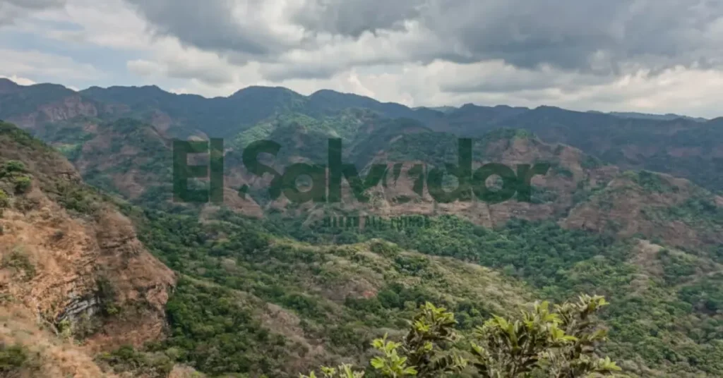
Parque Nacional El Imposible in El Salvador is one of those places that feels built for people who like their hiking honest and a little wild. I still remember the damp earth, the rush of rivers, and how the trails seemed to ask for steady legs and patience.
What makes it stand out is the mix of pristine rivers, archaeological sites, and campsites tucked into a landscape with real bite. The terrain is known to be challenging terrain, so this park tends to suit nature lovers who are comfortable with rough trails, longer days, and a trip that feels more rugged than polished.
I wish someone had told me earlier that this is also a good place to check your own pace before you go. If you’re trying to decide whether the park matches your fitness, time, and comfort level, that matters here more than most places. A taxi driver I met in the area said people come for the views, then realize the trail asks for respect.
Key Takeaways
- This park suits hikers who like rough, remote trails.
- The terrain can be steep, rocky, and tiring fast.
- Weather can change the route feel in a hurry.
- Plan your ride, water, food, and layers before you go.
- Safety matters, so keep an eye on your footing and timing.
Who Should Visit El Imposible National Park?
El Imposible National Park is best for people who like a real rugged park feel, not a polished day-trip setup. I remember hearing birds right before we hit a steep, dusty stretch, and the whole place felt wild and quiet at the same time. If you like hikers, nature lovers, birdwatching, and trail days that feel a little raw, this park fits well.
- Experienced hikers: Good match if you like uneven paths, heat, and trail difficulty that asks for decent fitness.
- Nature lovers: Great for people who want a remote park, big green views, and a slower pace.
- Birders: A strong choice if birdwatching is high on your list and you enjoy quiet mornings.
- Photographers: Worth it for mist, forest texture, and dramatic trail scenery.
- Travelers seeking rugged experiences: Ideal if you like places that feel less built up and more untamed.
It may feel less suitable for first-time visitors who want easy, paved, or highly developed trails. I wish someone had told me that the park is more about the hike than the amenities, because that changes the whole day. If you want a soft, simple walk, this probably won’t be your favorite stop.
What Makes This Park Worth the Journey?
The park’s main draw is how much it packs into one rough, beautiful landscape. You get pristine rivers, archaeological sites, campsites, and challenging terrain that turn a simple visit into a real hiking park trip for nature lovers.
- Pristine rivers give the park its calm, clear center. They shape the scenery and make the place feel wild, which is a big part of the appeal.
- Archaeological sites add a deeper layer. You are not just walking through nature, you are moving through a place with a long human story.
- Campsites let the trip stretch past daylight. That means quieter mornings, cooler evenings, and more time to take in the land.
- Challenging terrain is what keeps the park from feeling easy or polished. It asks for effort, and that effort is part of the reward.
Here’s the thing, this mix changes how the whole trip feels. The rivers soften the hike, the archaeology gives it meaning, and the rugged paths make every view feel earned.
How to Plan Your Visit Around Trail Difficulty, Weather, and Time
Trail difficulty, weather conditions, and hiking time should all shape the plan before you leave the hotel. I once chatted with a taxi driver who said, “People see a map and forget the mud,” and he was right.
Use this simple decision path:
- Short visit, pick the easiest route, skip side trails, and build in extra time for slow footing.
- Full-day hike, choose a moderate trail only if the forecast is steady and you have daylight to spare.
- Multi-day plan, check trail conditions early, then confirm water, shelter, and turnaround points before you go.
If the wet season has turned the ground slick or river crossings look high, I’d shorten the route or change plans. Park updates and local guides usually matter more than a pretty map here, because a trail that looks easy can feel much harder after rain.
Heat changes things too. In dry season, start earlier, carry more water, and favor shaded routes if the sun feels sharp on your skin. If the day is hot and there’s little shade, I’d cut the hiking time or wait for cooler weather.
If you feel rushed, tired, or unsure about river crossings, shorten the hike. If storms, deep mud, or high water are reported, postpone. If conditions are fair but not perfect, adjust the route and keep a clear turnaround point.
Trail Difficulty and Route Choice: Which Hike Fits Your Level?
Trail difficulty changes fast with steep terrain, a muddy trail, and how exposed the path feels in wind or sun. I once watched a taxi driver laugh and say, “Same mountain, three different moods,” and he was right.
Use the table below to compare each hiking route by what usually makes it feel easier or harder. If official park descriptions are available, trust those first, because navigation problems and weather can change effort more than the map suggests.
| Route option | Trail difficulty | Terrain | Time needed | Best use case |
|---|---|---|---|---|
| Lower or flatter route | Generally lighter effort | More even footing, usually less exposure | Usually shorter | Good for a relaxed day, mixed groups, or a first look at the area |
| Middle route | Moderate for many hikers | May mix steady climbs, narrow stretches, and some uneven ground | Usually longer than the easiest option | Best if you want a fuller hike without a big push |
| Upper or ridge route | Higher effort | Often steeper, more exposed, and more sensitive to wind or heat | Usually the longest and slowest | Fits hikers who want a tougher day and can handle route-finding |
| River-adjacent route | Can feel easy, but changes with conditions | Firmer in dry weather, but can turn slick near water | Varies a lot | Good for cooler walks, but watch for wet rock and muddy trail sections |
Here’s the thing, trail difficulty is not just distance. A short path can feel hard if it stays steep, gets muddy after rain, or asks for careful navigation through junctions and exposed edges.
Check weather before picking my route choice. A breeze on an open ridge feels harmless at the trailhead, but it can make a light hike feel serious fast, while shade, heat, and slick roots near water can do the same on a river-adjacent route.
So, I usually judge a hiking route by three things: slope, footing, and exposure. If two of those look rough, I treat the route like a bigger day, even if the distance sounds short.
Access, Entry Logistics, and Arrival Tips
Access usually starts at the main trailhead or park entrance, so don’t just follow a pin and hope for the best.
- Check the entry point first. Some sites have a signed main access road, while others use a small trailhead pull-off that is easy to miss.
- Plan your arrival time early. Morning arrival is safer for parking, cooler walking, and fewer last-minute delays at the gate.
- Confirm park rules before you go. Hours, access rules, and entry requirements can change, so verify them with official park or local tourism sources.
- Sort your transport in advance. If the road is rough, a suitable vehicle may help, and some places are easier with a driver who knows the route.
- Ask about guide needs ahead of time. Some trails are simple to follow, but remote areas or protected zones may be easier with a guide.
I wish someone had told me to save the trailhead name in Spanish, too. A local hotel staffer pointed out that drivers understand that better than a vague map label, and that saved us from one very awkward U-turn.
Safety Tips for Steep Ground, River Crossings, and Weather Shifts
Rugged trails can change fast. Steep rock, muddy ground, and rising water can turn a normal hike into a real problem, especially when heat, flash floods, or tired legs start piling up.
- Watch slippery trails closely. Wet roots, loose gravel, and shaded rock get slick fast. Short steps and slow footing helped more than rushing ever did.
- Check river crossings before you step in. If the water is moving fast, is cloudy, or comes above your knees, treat it as a warning sign and look for a safer route.
- Keep an eye on weather changes. Thunder, dark clouds, or sudden wind can mean flash floods are possible, even if the sky looks fine where you are.
- Start with hydration and keep drinking. Heat and dry air wear you down before you notice it. Sip often, and don’t wait until you’re thirsty.
- Use simple turnaround triggers. Head back if the trail gets too slick, water rises, you lose the path, or anyone in the group slows too much.
- Have a backup plan ready. Know the exit route, a safer bridge or crossing point, and the nearest shelter before you leave the trailhead.
- Protect your navigation. Phone service can fail in remote areas, so carry a map, check landmarks, and pause before junctions instead of guessing.
- Respect fatigue. Heavy packs, heat, and steep climbs can drain balance fast. A short rest is better than a bad slip.
I remember a ranger telling us, after we nearly pushed on through a brown, rising stream, that the smartest choice was turning around early. That kind of emergency planning feels cautious in the moment, but it’s what keeps a hard day from getting worse.
Best Time to Visit El Imposible National Park
The best time to visit usually depends on what kind of hike you want. During the dry season, trails are often firmer, streams are easier to cross, and visibility can be better for long views and route finding.
In the wet season, the park can feel completely different. Trails turn slick, river levels rise, and steep sections can get slower and more tiring. I remember a ranger joking that the mud was “the real entrance fee,” and honestly, it felt true after one very sticky climb.
Season also changes route choice. In dry weather, longer or more remote paths may feel more manageable, while wetter conditions can make shorter, lower routes the safer pick. That matters if you’re planning to cross streams or hike anything with lots of exposed rock.
| Season | Trail conditions | Hiking comfort | Route choice |
|---|---|---|---|
| Dry season | Firmer ground, easier footing | Less mud, but more heat | Better for longer and steeper routes |
| Wet season | Slick trails, higher river levels | Cooler air, but more strain and slower pace | Safer for shorter routes and careful planning |
Truth is, the dry season can feel hot fast, especially on open climbs. The wet season may feel cooler, but wet rocks, cloudy skies, and swollen crossings can make the day harder than it looks on paper.
What to Pack for a Hike in El Imposible
El Imposible gets muddy fast, and the heat can sneak up on you. We almost didn’t bring the right socks, and I still remember that damp, earthy smell on the trail after a quick rain.
- Sturdy footwear, with good grip for slick roots, steep dirt, and wet rocks.
- Water, plus a little extra. Remote trails can feel longer than they look.
- Water treatment, if you plan to refill from natural sources or camp overnight.
- Rain gear, because showers can roll in and turn trails into slick clay.
- Sun protection, like a hat, sunscreen, and sunglasses. The trail can feel hot and exposed.
- Bug protection, since insects can be annoying near влаж? wait can’t add that. Since insects can be worse in humid areas and near brush.
- Navigation tools, like a map, offline route, or GPS app. Cell signal can be weak in remote spots.
- Headlamp, even for day hikes, because delays happen and dark comes fast under the trees.
- First aid, with basics for blisters, cuts, and small scrapes.
If you’re camping, add your shelter, sleeping gear, and food plan too. I heard the same thing from a hotel staffer in the area and a couple of tired hikers, bring only what you can carry, because mud makes every pound feel heavier.
Camping Rules and Overnight Stay
Camping is only allowed where park regulations say it is.
- Where can campers stay? Usually only in approved campsites or other designated overnight stay areas, not anywhere you can pitch a tent.
- What facilities exist? Expect basic facilities unless official sources say otherwise. Do not assume showers, shops, or full campground services.
- Are permits needed? In most cases, yes if the park requires advance arrangements or camping permits. Check the official park administration or tourism source before you go.
- What should you expect? Keep your plans simple. Campsites may be quiet and rustic, with limited support and clear park regulations.
Verify the overnight stay rules first, because a ranger pointed out how strict the camping rules could be. If you want a spot, confirm the campsite details early and bring only what you need.
What You’ll See: Rivers, Wildlife, and Archaeology
The park’s rivers are often the first thing people notice. They shape the landscape, bring cooler air, and make the whole place feel alive.
- Rivers: Watch how the water changes with light and season. Pause near the banks, because the sound alone makes the walk feel calmer.
- Wildlife and birdwatching: Wildlife sightings can be part of the experience, and birdwatching may be rewarding where habitats are quiet and open. Keep your distance, move slowly, and let the animals decide the pace.
- Archaeological sites: These places matter because they connect the park to its cultural heritage. Look, don’t touch, and stay on marked paths so the sites stay protected for other visitors.
Travelers interested in deeper Salvadoran history sometimes also include the El Mozote Massacre Memorial alongside nature and archaeology routes.
What stayed with me most was how nature and history sit side by side. One ranger pointed out a trail edge to me, and a hotel staff member later reminded me that even small steps, like not stepping off the path, help preserve both the land and the stories it holds.
Travelers building a longer cultural route through the country often combine national parks with visits to El Salvador’s Maya ruins.
Sample Itineraries for Short Visits and Multi-Day Trips
The usual mistake is trying to do too much in one day. For planning, it helps to match the itinerary to your goal, whether that’s scenery, fitness, or camping.
- Short visit for scenery: Pick a simple day hike and keep the route timing loose. If you prefer slower nature stops after difficult hikes, Los Tercios Waterfall near Suchitoto is another easy add-on.
- Full-day option for fitness: Build a longer day hike around an early start, a steady walk, and a late lunch in town. Leave room for breaks, because the trail felt much easier once the morning heat passed.
- Multi-day trip or overnight for camping: If camping is allowed, plan an overnight so you can move slower and enjoy the evening quiet. That’s the version that usually gives you the most time for photos, camp meals, and a calmer route timing plan.
If you are exploring western El Salvador for several days, Tazumal ruins fit naturally into a hiking-and-history route.
How El Imposible Compares with Other Hiking Options in El Salvador
El Imposible feels more like a nature reserve than a casual day walk, with rugged terrain, thicker forest, and a wilder mood than many of the easier hiking options in El Salvador. I remember dust on my shoes, damp air under the trees, and that quiet stretch where even the birds sounded far away.
- Choose El Imposible if you want a bigger nature focus, steeper trail difficulty, and a sense of being far from the city.
- Pick a simpler hike if you care more about easy accessibility, a shorter outing, or a low-stress first hike. If you are staying near the capital before heading west, El Boquerón is one of the easiest volcano hikes near San Salvador.
- Skip the roughest parts if you are short on time, since the park’s remote feel can make the day feel longer than the map says.
Compared with more accessible outdoor spots, El Imposible asks for more energy and a little more planning. That tradeoff is worth it if you want raw scenery and a deeper forest feel, but a lighter hike may fit better if you just want fresh air and an easy start to hiking in El Salvador. If you want a lighter outdoor stop after difficult hiking routes, the Rainbow Slide El Salvador offers a more relaxed adventure experience.
Travelers comparing volcano hikes across the country often also look at Cerro Verde National Park for a different trail and forest experience.
Conclusion
El Imposible is best for hikers and nature-focused travelers who don’t mind rugged trails, changing weather, and a little extra planning. The steep paths, humid air, and quiet forest are what make it memorable, but they also mean you need to come prepared.
Check route difficulty, transport, and what to pack before heading in. A quick look at safety advice, water needs, and trail conditions can save a lot of trouble, and it makes the whole trip feel calmer once you’re out there.
Frequently Asked Questions
Who should visit El Imposible National Park?
It’s a good fit for hikers, bird watchers, and travelers who like quiet, green places. We almost didn’t go because it sounded rugged, but it ended up feeling calm and rewarding.
What makes El Imposible National Park worth visiting?
The park is known for steep trails, rich forest, rivers, and wide views. I still remember the damp air, the sound of insects, and how suddenly the hills opened up above the trees.
How do I plan a hike in El Imposible based on trail difficulty, weather, and time?
Pick a route that matches your fitness and the hours you have, then check the forecast before you go. Rain can make trails slick and river crossings harder, so early starts usually feel safer.
Which trail should I choose in El Imposible National Park?
The best trail depends on whether you want a short walk, a tougher climb, or a longer full-day hike. If you’re unsure, ask the park staff or a local guide which route fits the weather and your pace.
How do I get to El Imposible National Park?
Most visitors reach the park by road from western El Salvador, usually with a taxi, private car, or local transport to the entrance area. A hotel worker once pointed me to a driver who knew the road well, which saved time and stress.
Is camping allowed in El Imposible National Park?
Camping rules can change, so it’s best to confirm with park authorities before planning an overnight stay. If camping is allowed, follow posted rules closely and keep your site simple and clean.
What is the best time to visit El Imposible National Park?
The drier months are usually easier for hiking because trails are less muddy and crossings are more manageable. The rainy season brings greener views, but it also brings more weather risk.
What should I pack for a hike there?
Bring water, snacks, sturdy shoes, rain protection, sun protection, and a small first aid kit.
Is El Imposible suitable for first-time visitors?
Yes, if you choose a route that matches your experience and go with enough daylight. First-time hikers usually do better with an early start and a local guide, especially on steeper trails.
Are river crossings and weather changes a real safety concern?
Yes, they are. Sudden rain can raise water levels and make footing slippery, so check conditions before leaving and be ready to turn back if things change.
How does El Imposible compare with other hiking options in El Salvador?
It tends to feel wilder and more demanding than many shorter day hikes in the country. If you want forest, steep terrain, and a more remote feel, it stands out.
What wildlife, rivers, or archaeological features can visitors expect to see?
Visitors may see tropical wildlife, flowing rivers, and traces of the area’s long human history. On a quiet stretch of trail, we heard birds call from the canopy and passed spots that felt older than the path itself.